14 stops in the Property Viewer – press Start the tour, or play it from any stop below.
-
An untested gold showing in the Kirkland Lake camp
The Kirkland Lake camp has produced more than 23 million ounces of gold. On its western edge, the Eby–Otto property (about 285 ha) holds a showing that returned 14.04 g Au/mT over 0.40 m – and it has never been drill-tested. This tour shows where it is, what lies beneath it, and what is ready.
-
The camp and its breaks
Nine mines along the Kirkland Lake Break produced the camp’s gold. Agnico Eagle’s Macassa mine, still in production, is about 5.6 km north-east of the Reed showing. The claims lie west of the Amikougami Creek fault – where did the gold go when the western part of the camp shifted south?
Source: Camp production to 2018: Eby assessment report (2023)
-
424 metres from Macassa ground
About 285 ha: 10 claims and 5 mining leases. Agnico Eagle’s ground, including the Macassa patents, lies 424 m east of the Reed showing – a distance from the 2022 legal survey.
Source: Distance from the 2022 legal survey
-
The majors around us
Stardust Metals’ Kirkland West project adjoins us to the west, Agnico Eagle holds the ground to the east, and Barrick Gold holds claims about 6 km to the south-west.
-
The Reed showing – 14.04 g Au/mT, never drill-tested
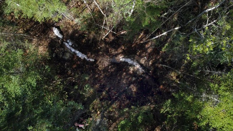
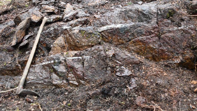
The Reed showing A gold–pyrite–albite zone. Three cut samples returned 14.04 g Au/mT over 0.40 m, and the Ontario Geological Survey’s own sample returned 8.02 g Au/mT over 0.61 m, and a 1994 grab sample from the showing returned 19.7 g Au/mT (AFRI 42A01SE0088). It has never been drill-tested.
Source: Cut samples 46707–46709; Ontario Geological Survey sample
-
Our best grab sample – 19.7 g Au/mT
Sample 5967, a grab from a gossan at the Reed showing in 1994, assayed 19.7 g Au/mT – a grab sample, not representative. Its lab certificate (Swastika Laboratories 4W-2199-RG1) is in the filed report AFRI 42A01SE0088. In 2017 an outcrop sample about 9 m away gave 18.8 g Au/mT over 20 cm. The Reed showing was never drill-tested.
Source: Swastika Laboratories 4W-2199-RG1 (1994); Actlabs A17-08209 (2017)
-
Not a single vein
The G vein, found in 2021 Stripping in 2021 found the G vein – about a metre wide with silicification, in a wide alteration zone – and extended the S vein to about 40 m. The cut grid from 1994–96 mapped the ground at 1:1000. Click a showing for its photos and assays.
Source: 2021 stripping; 1994–96 cut grid and mapping
-
High-grade gold at Boudreau
A historic grab sample of outcrop at the Boudreau showing reportedly assayed 1 oz of gold per ton – about 34 g Au/mT. It sits about 750 m west of the R vein. Doug Robinson's 2023 filed report says it points to the Cadillac–Larder Lake deformation zone being close by, and that it may have influenced where hole EO-22-004 was drilled, about 490 m west of the hole's deep intersection. The outcrop was hand stripped in 2021.
Source: Doug Robinson, 2023 filed report, AFRI 20000021754
-
A magnetic body starts right under it
The 2021 Aerial drone magnetic survey shows a strong magnetic body starting directly beneath the Reed showing, about 50–120 m down. No hole has tested it. Drag to turn the view.
Source: Aerial drone magnetic survey, 2021
-
A second signal: the 2022 IP survey
A 3D induced-polarization survey in 2022 measured chargeability – often a sign of sulphides – down to depth. Shown at about 220 m; the depth slider on the right steps through it.
Source: 2022 IP survey (Dias)
-
Drilled 1.8 km away – the showing was left untested
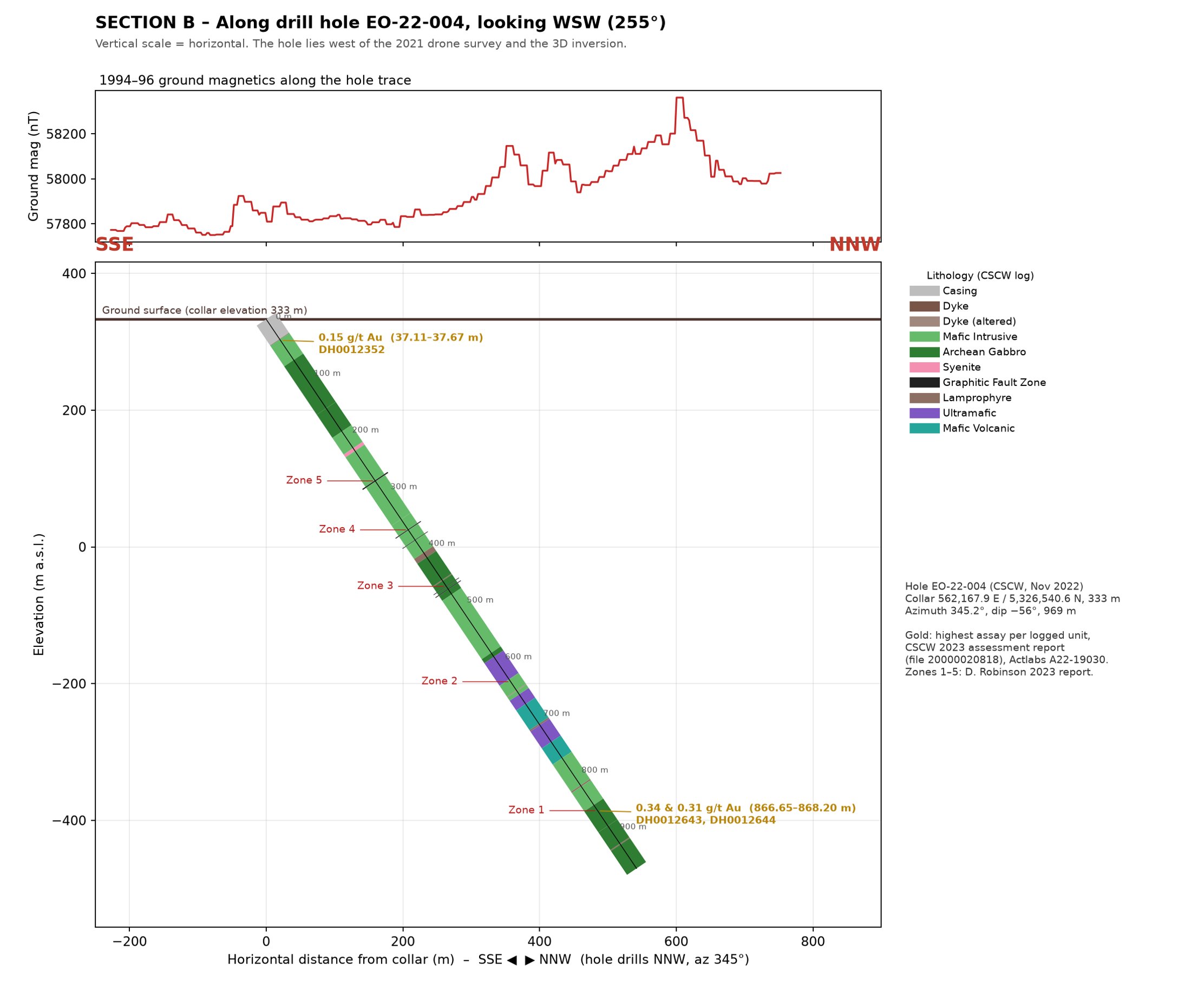
Hole EO-22-004 by rock type, with gold assays Hole EO-22-004 (969 m, 2022) was drilled about 1.8 km west of the showing, aimed at the deep break; its best result was 0.34 g Au/mT over 0.55 m. The 1984 holes were all short, 7–36 m. Neither the showing nor the magnetic body beneath it has been tested.
Source: Public assessment file 20000020818
-
The groundwork is done
Drill trails and cut pads from 2022 are still in place and reach across the claims. Highways 11 and 66 run beside the property, the Ontario Northland railway passes just north, a Hydro One line crosses it, and a lake just south-west of the claims can supply drilling water. An exploration permit is needed before drilling.
-
Thirty years of work, one map
$855,000 of approved assessment work since 1994: mapping, sampling, ground and drone magnetics, EM, IP, LiDAR and drilling – all in this viewer. Turn layers on and off, and click anything for its source.
-
Open to an investor
The Eby–Otto property is open to an investor. Explore any layer yourself, or ask us for investor access to the targets, the proposed holes and the full data room.